Topographic Survey: Your Land's 3D Blueprint
What's a Topographic Survey?
A topographic survey is a detailed and accurate mapping of the natural and artificial features of a specific area, including its terrain, elevation, buildings, roads, and other relevant elements, typically represented through contour lines on a map.
- Think of it as a high-definition snapshot of your land’s unique features – both the visible and the subtle.
- Here’s what I focus on:
- Elevation Points: Every peak and valley, mapped meticulously to show your land’s natural gradients.
- Trees and Vegetation: From the lone oak to a thicket of bushes, I record their locations, sizes, and types.
- Water Features: Streams, ponds, or lakes – if your land cradles water, I chart its shape and flow.
- Buildings: Whether it’s a cozy cottage or a robust barn, I capture the footprint of each structure.
- Roads and Paths: Every thoroughfare and hidden trail is plotted, showing access and connectivity.
- The result? A map that’s a window into the terrain of your property, offering a view that feels as deep and detailed as the land itself.
The Details I Map
Natural Features: I precisely document the land’s topography, including its waterways, vegetation, and elevation changes. Rivers and streams are outlined for their course and interaction with the landscape. I take note of the positioning and species of significant tree formations and the rise and fall of hills, detailing how the land naturally shapes itself.
Man-Made Structures: My surveying extends to capture the built environment within the land’s boundaries. Every building, regardless of size, is included to provide a complete overview of the area’s development. Roads and pathways are mapped to illustrate access points and routes through the property. Bridges, too, are detailed, showing their location and relation to the surrounding features.
How I Conduct a Topographic Survey
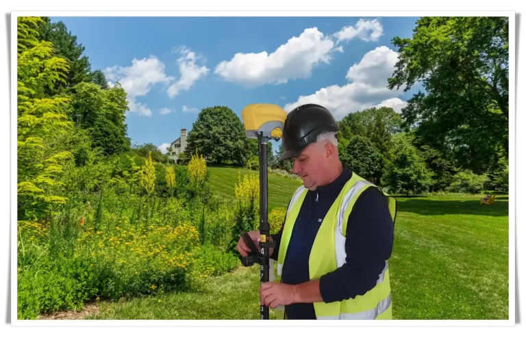
- Armed with a GNSS Rover, I survey the terrain, capturing precise geographical coordinates to map your property accurately. This advanced technology allows me to establish exact points with high precision, ensuring that the intricacies of your land’s profile are recorded with scientific accuracy.
- The Total Station is an integral part of my surveying toolkit. With it, I can measure distances and angles with remarkable precision, translating the physical reality of your land into a detailed and accurate topographic map. This instrument is crucial for creating a comprehensive representation of your land’s features, both natural and constructed.
The Process of Crafting Your Topographic Map
Step 1: Initial Reconnaissance
- Upon arriving at your property, I conduct a thorough walkthrough. With my surveying tools at hand, I assess the lay of the land, noting every detail that will contribute to the accuracy of the survey. This initial step is crucial for planning the most efficient surveying route and methodology.
Step 2: Precision Measurement and Recording
- With the GNSS Rover and Total Station, I begin the meticulous process of measuring. Every point is carefully selected and captured, ensuring that natural features and man-made structures are recorded with exactness. I approach this stage with a commitment to precision, as if painting a landscape where every brushstroke matters.
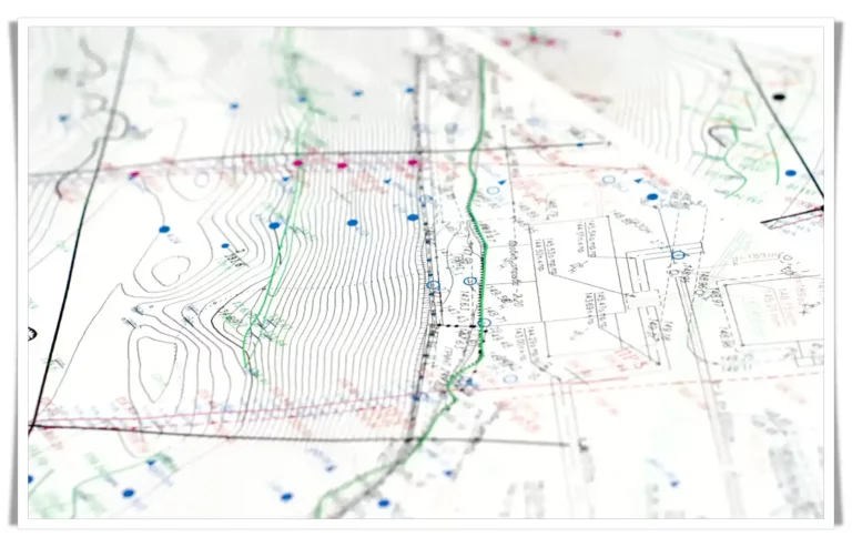
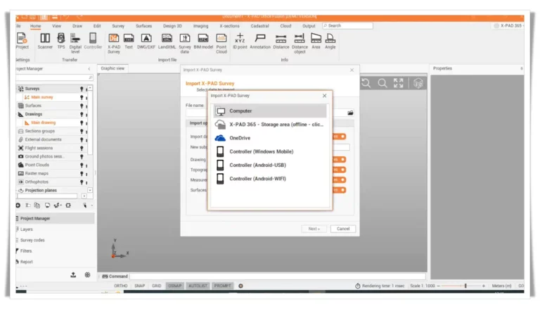
Step 3: Data Processing and Map Creation
- Back in the office, I process the collected data with specialised software. This is where measurements are transformed into a detailed and informative map. The raw data begins to take shape, contour lines form, and a true-to-scale representation of your property emerges. I refine the map to be both a precise tool for professionals and a source of insight for any observer.
The Importance of a Topographic Survey for Your Land
For Construction and Renovation Projects
- If you’re considering building a new structure or making significant alterations to an existing one, understanding the terrain is non-negotiable. A topographic survey provides the critical data needed to design with the landscape in mind, ensuring that your build is both feasible and sustainable.
When Buying or Selling Property
- Knowledge is power in real estate transactions. A topographic map arms you with detailed information about the property’s features, which can be a significant advantage in negotiations, helping to set or validate the asking price.
For Environmental Assessments
- Whether it’s evaluating potential flood risks or planning for environmental conservation, a topographic survey gives you an in-depth look at the natural aspects of the land, crucial for making informed decisions.
Landscaping Plans
- If you aim to transform the land aesthetically, a topographic survey helps you visualise and plan landscaping changes that complement the natural topography, resulting in a more harmonious and integrated outcome.
What a Topographic Survey Offers You
- A topographic survey is more than just ink on paper; it’s a powerful decision-making tool.
- It grants you the peace of mind that comes from knowing your land inside and out.
- It lays the groundwork for your future plans, ensuring they’re built on a foundation of accuracy and understanding.
Ready to Explore Your Land in 3D?
Ready to unlock the secrets of your land’s topography? Let’s start the conversation.
Share your vision with me, and I’ll transform it into a vivid reality, one contour at a time.
Get in touch for a detailed discussion and a customised quote. Because every piece of land has its own unique story, and I’m here to bring it to life.