Boundary Survey
What Is Boundary Survey?
A boundary survey is a detailed process conducted by a qualified surveyor to determine and mark out the true boundaries of a parcel of land. It involves the study and interpretation of title deeds, historical records, and previous surveys, combined with the physical measurement and marking of boundary lines on the ground.
The primary purposes of a boundary survey include:
- Clarifying Property Lines: It defines the exact extent of a property, helping landowners know where their property starts and ends.
- Supporting Land Transactions: Before buying, selling, or subdividing land, a boundary survey ensures that the land area being transacted is accurate.
- Resolving Disputes: If there are disagreements between neighbouring property owners regarding where one property ends and another begins, a boundary survey can provide clarity.
- Planning and Development: For construction or developmental projects, knowing the exact boundaries ensures that all activities are within the property limits.
The result of a boundary survey is typically a detailed map or plan that depicts the property’s boundary lines, corner markers, and any related easements or encroachments.
Understanding Property Boundaries:
- Have you ever wondered about your property boundaries?
While it might not be something you think about every day, knowing your boundaries can be crucial, especially when considering home insurance claims.
- How can you find your property boundaries?
The specific boundaries might not always be clear, especially when considering features like fences, walls, or hedges. However, the boundary lines should be indicated on your property’s title plan. insurance claims.
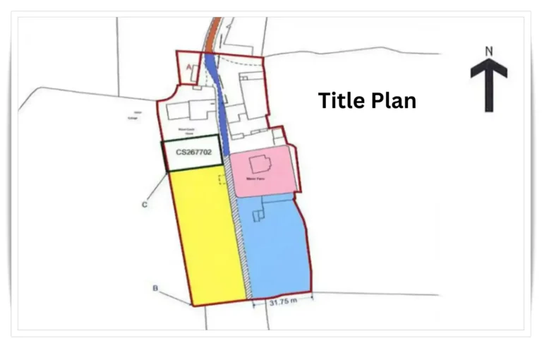
- What exactly is a title plan?
It’s a map crafted by the HM Land Registry that outlines your property using red lines on Ordnance Survey maps. When you purchase a property, the HM Land Registry provides this, either electronically or in paper form for older properties. If you’ve misplaced yours, you can order a copy from the HM Land Registry’s Find a Property service, usually for around £3.
Potential Boundary Issues:
Occasionally, challenges arise when determining your property’s boundaries. You might need to check your title plan for:
- Changes to party walls
- Adjustments to the established boundary
- Upcoming repair projects
- Disputes about land ownership
For instance, shared driveways can lead to questions about maintenance responsibilities. Or, if a tree on a neighbour’s property damages your home, who foots the bill? Knowledge about your boundaries can help navigate these issues.
Tips to Avoid Boundary Issues:
Discuss with Neighbours: An informal conversation can clear up many disputes before they begin.
Apply for a Determined Boundary: This official record, agreed upon by both you and your neighbour, can update the official title plan and safeguard both parties in future transactions.
Always Get a Survey When Buying: Property surveys can alert you to past boundary disputes and help you avoid future issues.
Debunking Fence Myths:
Discuss with Neighbours: An informal conversation can clear up many disputes before they begin.
Apply for a Determined Boundary: This official record, agreed upon by both you and your neighbour, can update the official title plan and safeguard both parties in future transactions.
Always Get a Survey When Buying: Property surveys can alert you to past boundary disputes and help you avoid future issues.
Handling Fence Responsibilities:
If a fence gets damaged and ownership isn’t clear:
Split the Cost: A common solution is for neighbours to share the repair expenses.
Establish a Boundary Agreement: Unlike a determined boundary, this agreement specifies fence ownership and responsibilities for both parties.
Once responsibilities are clear, property maintenance becomes simpler and neighbourly disputes become less likely.
Conducting a Boundary Survey & Reporting:
- The objective of a Boundary Survey:
- To determine the true property boundaries and identify any potential discrepancies or encroachments.
Importance of Expertise:
- The process isn’t just about measuring; it requires understanding local laws, past property records, and sometimes even historical data.
- Employing a professional with a keen understanding of UK land regulations ensures the legitimacy of the findings.
Steps Involved in the Survey:
- Initial Research: Before heading to the site, surveyors delve into historical records, previous surveys, and any relevant legal documents.
- On-Site Examination: Surveyors use specialised tools and techniques to physically measure and mark the boundaries on the land.
- Potential Discrepancies: Any inconsistencies between recorded and actual measurements are noted, potentially leading to further investigations.
Creating the Report:
- Introduction: The report often starts by outlining the purpose of the survey and the methodology employed.
- Detailed Findings: A comprehensive account of the measurements, marked boundaries, and any observed discrepancies.
- Visual Aids: Maps, diagrams, and sometimes photos are incorporated to visualise the findings better.
- Recommendations: If discrepancies were found, the report would provide suggestions or next steps.
Utility of the Survey Report:
- Legal Grounding: The report can serve as a point of reference in any boundary-related disputes.
- Development Plans: Knowing precise boundaries is crucial for construction or landscaping ventures.
- Property Sales: Provides clarity for potential buyers about the extent of the property.
Revisions & Updates:
- Land dynamics can change over time, so it’s essential to consider periodic resurveys and report updates.
Bottom Line:
- A boundary survey is not a DIY project. Rely on qualified professionals who understand the intricacies of boundary determination, ensuring the results are accurate and adhering to UK regulations.